MATTEO TAVAZZI
Architecture - Landscape - Urban Design

UNFINISHED INFRASTRUCTURES
2015 - San Giorgio Piacentino, Piacenza (Italy)
Team: Tamburini Fabio - Tavazzi Matteo
Supervisors: Paolillo Pier Luigi - Quattrini Giuseppe
Landscape & Urbanism
Trying to solve the problem of the unfinished infrastructures in Italy, was taken into consideration the case study of S.P.6 S.Polo-S.Giorgio in the province of Piacenza in order to develop a reusable method of operation in each similarly context, justified by a scientific solid basis. The definition of such a method has had as a starting point the study of the plan documents of the municipalities concerned by the unfinished work to get a first superficial analysis of the territory. Then the examination of other case studies of urban plans which are known as virtuous example for the experts on the subject, as the Barzio plan and the Martinengo plan. These were useful to understand the system of the multivariate analysis and GIS. Finally it has been defined the method in accordance with the road network design guidelines of the Emilia-Romagna region, this method led to the drafting of an alternative project solution.
The research work was presented as a thesis for Bachelor’s Degree
Opere Viabilistiche Inconcluse
Il caso piacentino della tangenziale San Polo/San Giorgio sulla S.P. 6, analisi del progetto e proposte alternative per un nuovo inserimento paesaggistico
Introduction
In 1995 the very first project for the new tangential road passing by S. Giorgio and S. Polo have been proposed.
Until 2008, when the construction site have been settled, no other proposal have been made.
In 2008 the economic situation has changed compared to the one of the 1995. This condition has given the basis to understand what could happen in the future of this project.
The drawing of the new road is also following a very strange path inside the countryside, cutting existing edges shaping in a very irregular way the agricultural landscape surrounding.
A fundamental role in this particular case is represented also by the relationship between the road authorities.
Anas S.p.A. instructed Centro Padane S.p.A. to build and manage the stretch of motorway from Piacenza to Brescia and the related roads for the accesses. Among them also the S.P.6. The contract expired in 2012 and it has never been renewed.
Centro Padane S.p.A. secured the worksites and closed them. Since that moment they are abandoned.
The existing proposal is also passing through two different areas that are subjected to a environmental conservation that weren't respected.
The definition of a method that can be considered correct is divided into three different parts, the study of the previous project, the execution of the works and the use of the infrastructure.
The new project considers just the first aspect, in order to propose a new alternative.
The chosen approach includes studies of environmental characterization and consolidates all the elements composing the different existing environment conditions, trying to adapt the new proposal following the peculiarities of the context surrounding.
the aim of the new drawing of the road is to try to reconnect and restore all those pieces that in the past represented an homogeneous fabric into the agricultural scenery.

The concept of Integrated Design can be really useful in understanding the design method.
The Integrated Design is partecipative, all the characters cooperating, are involved into the realization of the final result; it can be considered as the first step towards a sustainable design, in which from the very beginning strengths and weaknesses, corrections and modification are analyzed in order to achieve a definition of the project that comprehends all the factors, under economical, social and cultural point of view.

Regarding road design the different environments surrounding have to be take into account and to describe the landscape in which the new road is going to settle its path, three different "contexts" had been chosen among those that the Emilia Romagna Authorities defined and proposed into their guidelines.
Il primo ambito considerato è quello della pianura, che viene identificata nel territorio a nord della via emilia, in questo territorio si alternano centri abitati e una fitta rete di infrastrutture che ricalcano la scansione regolare dell’orditura della centuriazione.
Design method
Context 1
The first area considered is that of the lowland, which is identified in the territory north of the Via Emilia, in this territory there are inhabited centers and a dense network of infrastructures that trace the regular scanning of the warping of the centuriation.
There are points of land structure and others considered critical, among the first include the different farmhouses, historical and noteworthy, among the critical points of the territory is instead the problem of this alternation between the different elements, which precisely for this "disorder" risks to be lost.
The basic objectives to solve these problems are aimed at finding solutions that can lead to high functional performance, guaranteeing a high level of sustainability with respect to the ecological connection components.
The resolutive proposal finds as a solution to this problem the "Crossroads" as an element superimposed on the existing plot, trying to connect the infrastructural network with the territory, while improving the functionality of the traffic flow.
Context 2
The second area, that of the hills of Piacenza and Parma is characterized by the regular sequence of river valleys characterized by extensive agriculture, pastures and historic vineyards. The criticality of this context is given by the ecological emergencies of existing systems that alternates open views on river and visual terraces closed in the crossed woods.The elements structuring the landscape are given by the S.S.45 which offers along its route an itinerary that crosses different geological formations and naturalistic landscapes of great effect dotted with small characteristic settlements.
The underlying objectives must therefore reinforce these characteristics while maintaining values of high environmental sustainability. This is why, based on regional planning tools such as PRIT, PTPR and provincial PTCP and projects of Agenda 21, the "Terrace" is proposed as a solution to these objectives, in such a way as to connect the need for a functioning road network with respect for environmental factors and tourism development projects.
Context 3
The third area, that of Via Emilia is analyzed together with the concept of a "Sustainable tangential road".
In this part, the problem of crossing small and large urban centers, which alternate with large stretches where the predominant landscape is the agricultural one, is underlined. The major criticality of this context is precisely the fact that urban centers alternate with the agricultural system, which in view of the expansion is likely to get lost, for this reason the design solution that is proposed is that which is considered a sustainable tangential road.
That is a system for which it is the infrastructure itself that determines the boundary of the expansion, thus going to preserve the agricultural landscape that surrounds the population centers.
Design of the new proposal
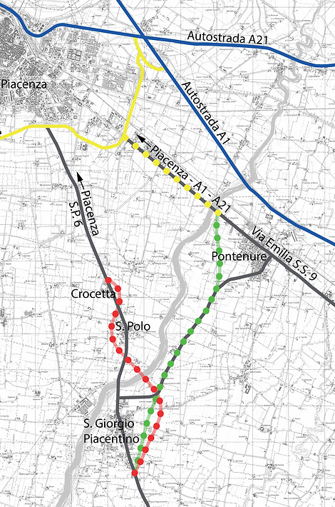
The creation of a new path proves to be the most effective proposal to ensure that the territory is not altered by an infrastructure of this type. It is therefore proposed a new path that tries not to affect the existing mesh and warp, but instead takes advantage of the historical paths. To do this the new proposal present a route that exploits the road that connects San Giorgio Piacentino to Pontenure, starting from the S.P.6 on the South of San Giorgio and arriving on the S.S.9 on the North of Pontenure. This choice is due to the fact that this route bypasses the traffic lights of the municipality of San Giorgio that create daily disruption to traffic, moreover through an already existing roundabout will be connected to the Via Emilia, which has recently been modernized, in this way the vehicular traffic is diverted on a working road that leads directly to the new external ring road of Piacenza and to the most important highway system of the territory, in the junction of A1-A21.
Tranche 1
Regarding the first portion of the route, it is noted that the new route follows a more regular course, in fact, unlike the original design, it follows a more congruent drawing, coherent with the existing agricultural image.
Moreover, with this path a new infrastructural system allows to delimit and contain the urban expansion through a sequence of tree-lined avenues, in order to connect the town and the countryside that surrounds it.


Tranche 2
The original layout is completely detached from the context, drawing a series of arches around the inhabited centers, and crossing the Nure torrent, an area subject to landscape constraints.
According to the alternative route the existing road is re-used, widening the section.
The net of all the historical roads inside the agricultural landscape is preserved through a system of underpasses, that connect all the services to the rural activities.


Tranche 3
In the third portion the agricultural mesh is the most possible traced, Finding solutions that do not affect the productivity and exploitation of the fields.
The connection with the Via Emilia takes place through an already existing roundabout, which brings the vehicular traffic on the new system of ring roads surrounding Piacenza, from which the different areas of the city center and the large A1-A21 motorway can be quickly reached.


Conclusions
The result of this new proposal is a design that is not detached from the context and especially does not affect the mosaic of habitats and the landscape sensibility of the place. Instead, all these elements are again recomposed, going to blend characteristics of the historical and social context with landscape features that respect the shape of the surroundings. The infrastructure therefore tries to be a connecting element rather than a caesura between the places.

